📍 Join us at IAM Madrid – Expodrónica 2025, June 11–13, for the live unveiling of our new drone logistics applications!

Modern logistics systems are being pushed to their limits. With the surge in e-commerce, increasing pressure for just-in-time delivery, and a growing demand for resilient and sustainable transport models, conventional ground-only logistics often falls short—especially in rural areas or for critical deliveries that require precision and speed. Meanwhile, the evolution of drone technologies and electric vertical take-off and landing (eVTOL) aircraft has created enormous potential to transform supply chains. Yet, despite technological maturity, drone logistics remains largely siloed—hampered by regulatory complexities, fragmented planning tools, and insufficient integration with the broader logistics infrastructure.

WINGWAY II, a multi-partner R&D project led by ALIA (Aragón Logistics Cluster) with funding from Spain’s Ministry of Industry, set out to change that. The mission: demonstrate a viable, selective multimodal logistics model where drones and ground fleets collaborate efficiently and safely across shared delivery networks.

At Skymantics, our role was clear: develop the digital backbone that makes this integration operational, smart, and safe.

Engineering Intelligence for Multimodal Logistics

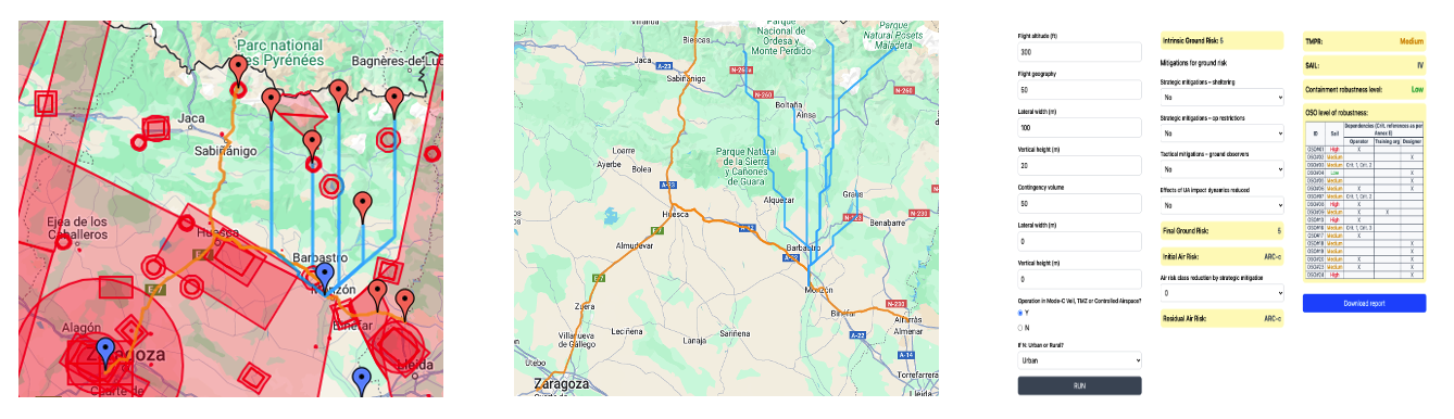
To realize the WINGWAY II vision, Skymantics developed a suite of three interconnected software applications. These tools empower logistics operators to plan and execute drone-inclusive delivery routes with economic efficiency, regulatory compliance, and real-time adaptability.


Multimodal Cargo Delivery Planner

This application is the cornerstone of the logistics planning workflow. It enables operators to design hybrid delivery routes that combine traditional ground transportation with drone segments, based on economic, spatial, and infrastructural parameters.

  • GIS-Based Interface: Users interactively define delivery points, assign trucks and drones, and map out vertiport hubs.

  • Route Optimization Engine: Calculates the most cost-effective route combinations using advanced optimization algorithms.

  • Airspace and Infrastructure Integration: Connects to AESA’s airspace regulation API to ensure compliance with current flight restrictions.

  • Output Reports: Provides multimodal routing instructions and cost breakdowns, helping reduce operating costs while expanding reach.

Weather-Based Drone Route Optimizer

Safety is the bedrock of aviation. This application ensures that the aerial components of a delivery mission are flightworthy under real-time atmospheric conditions.

  • Weather Data Integration: Aggregates real-time METAR reports and live sensor feeds via TruWeather Solutions API.

  • Route Hazard Analysis: Detects and flags weather anomalies that threaten drone stability—especially crosswinds and wind gusts beyond safe thresholds.

  • Operational Adjustment: Suggests re-routing or timing adjustments to avoid turbulent air pockets, ensuring mission safety without unnecessary delays.

  • Visualization Layer: Overlays risk zones and sensor data on the same GIS platform used by the planner.

Drone Mission Risk Assessment Tool

Our third tool automates the complex safety assessment process, transforming regulatory obligations into operational advantages.

  • JARUS SORA Framework Implementation: Calculates the Specific Assurance and Integrity Level (SAIL)  by assessing ground and air risks from terrain, population density, proximity to critical infrastructure, and contingency areas.

  • Mitigation Planning: Supports user mitigations (e.g., parachute systems, detect-and-avoid, geofencing) and offers built-in support for contingency planning.

  • Automated Documentation: Generates downloadable SORA reports and ConOps summaries, accelerating repeatable approvals and operational readiness.

  • Live Air Risk Integration: Supports live air traffic feeds via ADS-B infrastructure, evaluating mid-air collision risk dynamically.

See It Live at IAM Madrid – Expodrónica 2025

We’re thrilled to announce that we will unveil these three applications at IAM Madrid – Expodrónica 2025, taking place June 11–13 at Aérodromo de Ocaña and Madrid. Come see our applications live during the flight demo, and connect with our team to discuss partnerships, demos, and pilot deployments.

This is more than a technology showcase—it’s the beginning of a new phase of logistics, where air and ground delivery systems work in unison, powered by real-time data and smart planning.

About Skymantics

Skymantics is an innovative professional and technical services firm delivering custom solutions to support customers’ needs while supporting interoperability and standards. The company incorporates emerging technologies and agile methodologies in a rapid-prototyping approach to support domains in aviation, geospatial intelligence, and data analytics.

Would you like to learn more?

Feel free to Contact Us, we’ll be happy to help!

Share:

Related posts

Skymantics Leverages DataGenesis to Power Next-Gen European Digital Twins with High-Fidelity Synthetic Populations

Skymantics Leverages DataGenesis to Power Next-Gen European Digital Twins with High-Fidelity Synthetic Populations

Zaragoza, Spain / ACCESS Newswire / February 16, 2026 / Skymantics Europe’s DataGenesis platform supports the evolution of European Digital Twins. By providing high-accuracy, high-resolution synthetic population datasets, DataGenesis enables…

From ‘What Is’ to ‘What If’: Simulating the Future of Food Supply Chain Resilience

From ‘What Is’ to ‘What If’: Simulating the Future of Food Supply Chain Resilience

In this series, we’ve explored America’s “hidden hunger” and the need to understand vulnerable populations. But knowing who is vulnerable is only half the battle.…

From Food Security to future populations: The challenge of planning in a World on the move

From Food Security to future populations: The challenge of planning in a World on the move

In my last article, I explored America’s hidden hunger crisis. But ensuring food security is just one piece of a much larger puzzle. How can…